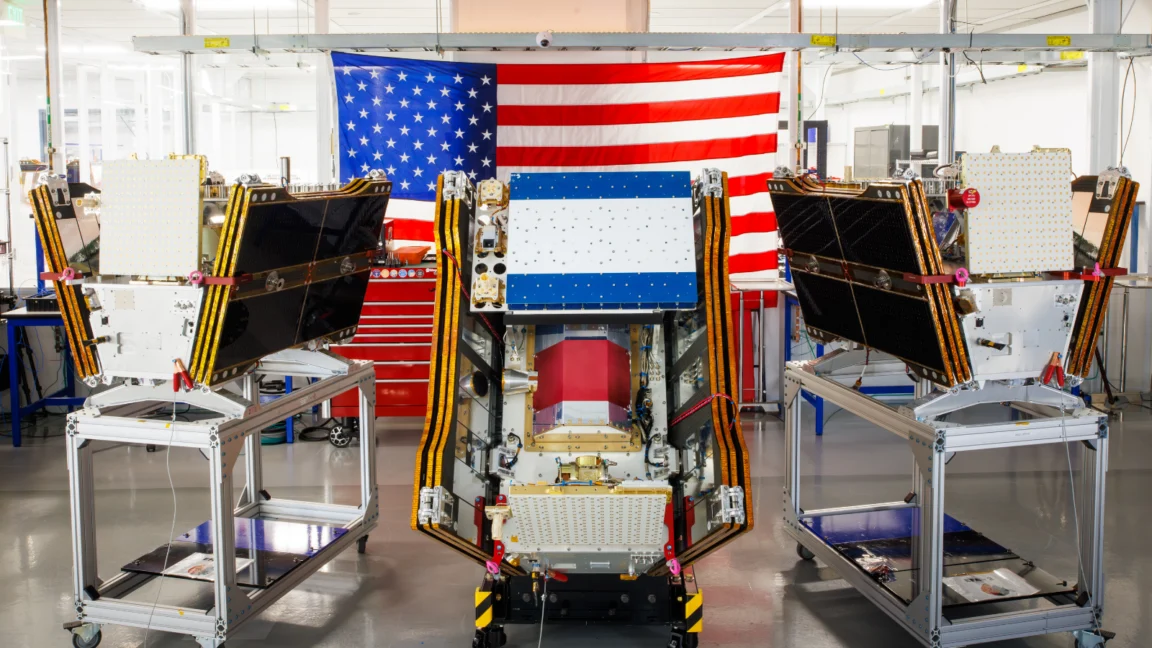
The first three operational satellites of the FireSat program, a Google-backed initiative designed to revolutionize wildfire detection, successfully entered orbit on July 7, 2026. Launched aboard a SpaceX Falcon 9 rocket from Vandenberg Space Force Base in California, these microsatellites are poised to significantly bolster efforts to combat the growing threat of wildfires across the United States, Australia, and Europe. The program, managed by the nonprofit Earth Fire Alliance, aims to provide unprecedented early detection capabilities, capable of identifying fires as small as five by five meters, even through dense smoke and cloud cover.
The deployment marks a critical transition for the FireSat constellation to "initial operational capability." Following a three-month calibration and testing phase, the satellites will commence active data collection, offering comprehensive coverage of every fire-prone region on Earth at least twice daily. This development arrives at a crucial juncture, as vast plumes of smoke from a catastrophic wildfire season in Canada and the United States have choked skies and posed significant health risks to millions.
A New Era in Wildfire Monitoring
FireSat represents a groundbreaking leap in satellite technology, being the first constellation specifically engineered for the sole purpose of detecting wildfires. Unlike previous satellite systems that often struggle with the challenges posed by smoke and atmospheric conditions, FireSat’s advanced multispectral imaging capabilities allow it to "peer through" these obscuring elements. This ability is crucial for identifying nascent blazes that might otherwise go unnoticed by conventional monitoring methods.
The development of FireSat has been a collaborative effort, with California-based satellite manufacturer Muon Space designing the advanced microsatellites. Financial backing for the initial deployment has been substantial, with Google contributing over $15 million to the project. Further bolstering the initiative, the Bezos Earth Fund has committed an impressive $26 million, underscoring the widespread recognition of the urgent need for enhanced wildfire detection and response.

Proven Technology and Future Expansion
The efficacy of FireSat’s technology was demonstrated by a Protoflight satellite launched in March 2025. This precursor mission successfully collected over one million images, validating the system’s ability to detect low-intensity fires that were invisible to existing satellite technologies. These early successes have paved the way for the operational deployment of the constellation.
The Earth Fire Alliance has identified a cohort of "early adopter" organizations that will begin utilizing FireSat data this year. These include prominent fire agencies in California and Colorado, alongside international partners in Australia and Portugal. As the constellation expands, the program’s ambition grows. By 2029, FireSat aims to deliver near real-time imagery from anywhere in the world on an hourly basis. The ultimate goal is to achieve an hourly or even sub-hourly revisit rate once the full constellation of over 50 satellites is launched in the early 2030s.
Quantifiable Impact and Economic Benefits
The implications of FireSat’s advanced detection capabilities are profound, with significant potential to mitigate the devastating economic and environmental impacts of wildfires. The Earth Fire Alliance projects that even an hourly revisit rate could lead to annual savings exceeding $1 billion in fire damage costs. Furthermore, it could prevent the release of nearly 22 million tons of carbon emissions, while safeguarding approximately 3,500 homes and an estimated 1.3 million acres of land.
Google Research is also playing a pivotal role in maximizing the utility of FireSat data. The company plans to leverage its sophisticated AI models to cross-reference operational FireSat imagery with historical data. This AI-driven analysis will enable highly accurate identification of even the smallest fires and contribute to the development of more robust predictive wildfire modeling. Google has lauded the launch as "another tangible step forward in putting practical AI to work for climate resilience."

The Shadow of Climate Change on Wildfire Activity
While FireSat offers a beacon of hope in the fight against wildfires, the underlying causes of their escalating severity cannot be ignored. The increasing frequency and intensity of wildfires are inextricably linked to global climate change, driven by the relentless emission of greenhouse gases from human activities, primarily the burning of fossil fuels.
This connection is starkly evident in the recent wildfire seasons. Canada, in particular, has experienced some of its most destructive fire seasons on record in 2023 and 2025, with the last three years ranking among the ten worst. Scientists have been warning for decades that a hotter and drier climate would significantly elevate wildfire risks, overwhelming traditional fire suppression strategies.
The energy demands of the burgeoning AI sector, including the massive data centers required to power advanced models like those employed by FireSat, present a complex challenge. These facilities often rely on electricity generated from fossil fuels, contributing to the very climate change that exacerbates wildfire threats. Google itself has acknowledged the strain on clean energy resources, with its company-wide electricity consumption experiencing a significant 37 percent increase in 2025, partly due to its AI buildout.
Challenges in Wildfire Suppression
The sheer scale and ferocity of recent wildfires, such as those that have ravaged Canada’s boreal forests, have highlighted the limitations of traditional suppression methods. Thousands of individuals from First Nations communities have been forced to evacuate their homes due to fast-moving blazes. The resulting smoke has blanketed vast swathes of Canada and the United States, leading to hazardous air quality for over 100 million people.

Effectively combating fires in remote, uninhabited forest regions necessitates specialized aerial resources, including fixed-wing air tankers and heavy-lift helicopters capable of delivering fire retardants and transporting firefighting crews. However, the responsibility for acquiring and maintaining these assets often falls on individual Canadian provinces, which have faced increasing strain in recent years. To address this, the Canadian government has leased 10 new aerial firefighting aircraft to bolster nationwide response capacity.
As of July 17, 2026, the Canadian Wildland Fire Information System reported nearly 900 active wildfires across the country, with over 3,600 fires having already burned more than 6.6 million acres. The difficult reality for many fire agencies is that a significant number of these fires are classified as "out of control" and are being monitored rather than actively suppressed. This strategic decision is a direct consequence of limited resources and the paramount need to prioritize firefighter safety.
Broader Implications and the Path Forward
The deployment of FireSat represents a critical technological advancement in our capacity to monitor and respond to wildfires. However, it is essential to recognize that early detection is only one component of a comprehensive wildfire management strategy. Effective wildfire prevention and mitigation also require robust ecosystem management, including prescribed burns, and adequate resources for direct suppression efforts.
The synergy between advanced satellite technology, like FireSat, and artificial intelligence, as championed by Google Research, holds immense promise. This integration could revolutionize how we understand, predict, and combat the escalating threat of wildfires. Yet, this technological progress must be viewed within the broader context of the climate crisis. Addressing the root causes of climate change through a transition to clean energy and sustainable practices remains paramount to truly mitigating the devastating impacts of increasingly severe wildfire seasons.
The vision for FireSat is ambitious: to provide global, near real-time wildfire data that empowers communities and governments to act decisively. As the constellation continues to expand, it signifies a significant investment in climate resilience and a testament to the power of technological innovation in confronting one of the most pressing environmental challenges of our time. The coming years will be crucial in determining how effectively this new generation of wildfire detection technology can be integrated into broader efforts to protect lives, property, and invaluable ecosystems from the destructive force of uncontrolled fires.